
7th - 8th October 2024
QGIS Course Series #1

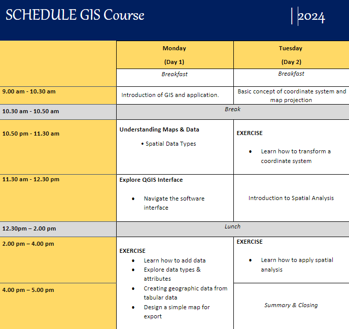
Course Content
Introduction and application to GIS
Basic concepts of Coordinate systems, projections, and data formats.
Introduction to cartography: map and mapping technique
Introduction to spatial analyses
Data visualization and maps


Focusing on the integration of QGIS software for geospatial analysis and data processing. This workshop is designed for those eager to learn the theoretical foundations and practical processing techniques within QGIS, tailored to enhance your GIS project outcomes.
Participants will dive into QGIS fundamentals, including spatial data management, geoprocessing tools, and map visualization. The workshop will cover essential topics such as data import and organization, vector and raster analysis, spatial queries, and best practices in project setup and data processing workflows.
With a strong emphasis on theory and software application, this workshop is perfect for beginners and intermediate users looking to refine their skills in QGIS without the need for on-field sonar operations. Gain insights into effective project planning, data quality control, and interpretation techniques crucial for any GIS project.

SCHEDULE
Monday to Tuesday (7th - 8th October 2024)

Location
Kuala Terengganu Drawbridge
Address
Ocean Research Services / Ocean My Level 1, DUA, Dapo Pata Tok Jembal, Jalan Longgok, 21300 Kuala Nerus, Terengganu Darul Iman
Email us at
me@oceanmy.net
Phone/Whatsapp
Yana (+6013 400 9856)
Farah (+6019 329 4645)
Contact Us